Four Routes to choose from:
Complete Century (101 miles, 6400 ft climbing – with 85 mile, 5100 ft climbing option): Start at Ohlone College in Fremont and ride north to Niles Canyon Road (there will be CHP presence in Niles Canyon), to Palomares Road. Ascend Palomares’ cool canyon and at the top enjoy a 5 mile long, beautiful downhill to Palomares Elementary School and a well-stocked rest stop. From there travel the historic Lincoln Highway over the Dublin grade to Dublin and then work your way down Foothill Rd and over to the Rios-Lovell winery rest stop, past vineyards and windmills to the top of Altamont Pass, looping back to lunch at a winery. From there go to Sunol Glen School for another rest stop then up Calaveras Road, and cruise alongside beautiful Calaveras Reservoir, this year going down “The Wall” (life is good!). Continue a three mile long downhill to the Spring Valley Volunteer Fire Department rest stop and back to Fremont for a hearty meal. (The 85 mile option bypasses the loop to Altamont Pass, going straight to the winery for lunch).
100K (62 miles, 4200 ft climbing): Same as Complete Century, but skips the loop through Livermore and Altamont Pass, while adding a nice loop through Happy Valley.
Calaveras Loop (38 miles, 2400 ft climbing): A nice moderate ride. Same as the 100k but shorter by bypassing Palomares and Dublin Canyon and going directly to Sunol rest stop via Niles Canyon. There will be a CHP presence in Niles Canyon to insure your safety. You’ll get to enjoy some of the finest scenery in all our rides along Calaveras Reservoir.
Fun Ride (28 miles, mostly flat, 640 ft): Pedal to Coyote Hills Regional Park return using parts of the Alameda Creek Trail on this mostly flat, fun and educational ride. Experience the FUN of an organized ride! Suitable for newer riders, or those riders just returning to bicycling.
Route Arrows:
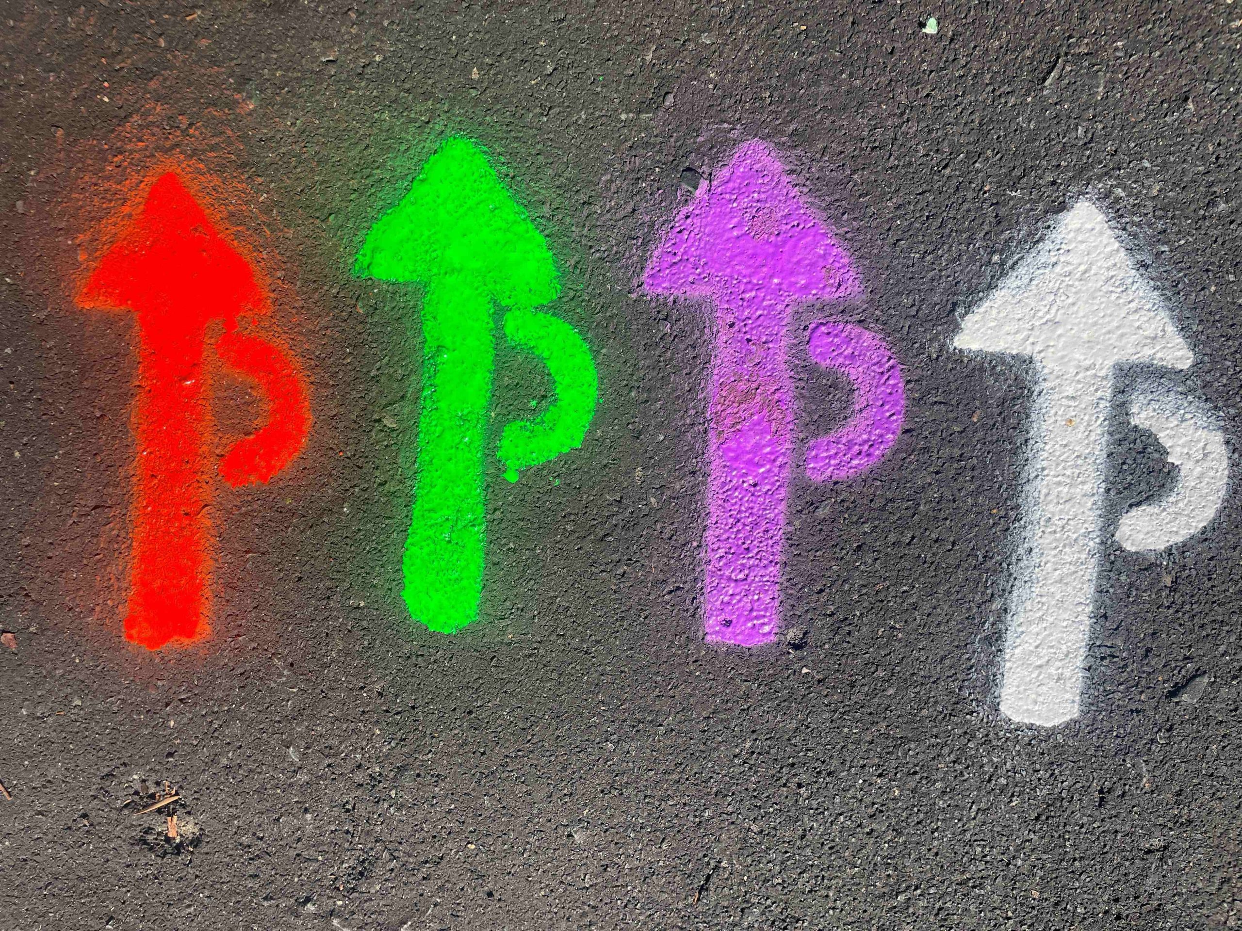
100 mile/85 mile — 100 km — 38 mile — 28 Mile
Orange — Green — Lavender — White
NOTE: There may be other markings on the road that look similar. Look for the “P” as part of our marking.
Safety and SAG support:
SAG contact Number: 510-279-6082
We will have numerous Course Marshall’s positioned along the route for safety. In addition, our SAGs will be patrolling all routes and will be in contact by radio with our base station in case they need to be directed somewhere quickly. SAGs will be carrying some bike repair equipment – if additional repair is required, they will deliver you to a mechanic at the next rest stop.
eBike policy:
Class 1 and 3 (pedal assisted) eBikes are allowed on all rides. Class 2 (throttle assist) are NOT allowed on any rides.
Lost and Found:
During the event: check at the Bag Drop pickup area.
After the event: email primavera@ffbc.org.
Read the Travelogue for the full route description and highlights!
![]()